Early in the sixth century, as the Aksumite king Kaleb prepared to make war across the Red Sea, he sent an unusual request to Asbas, his governor at Adulis. Two ancient monuments stood outside the city: a stela inscribed with the campaigns of Ptolemy III Euergetes and, before it, a marble throne bearing the victories of another, unnamed ruler. Kaleb wanted copies. Asbas entrusted the work to two Greek-speaking visitors: Cosmas, later called Indicopleustes, “the Indian traveller,” and his companion Menas.1
The scene compresses centuries of Red Sea history into a single act of transcription. A Christian king planning an Arabian expedition asked a provincial official to recover the words of earlier conquerors. A merchant became an epigrapher. Monuments erected in different periods shared a ceremonial landscape in a working port. Cosmas even reports that local authorities carried out public executions before the throne. At Adulis, the past was not inert. It could be inspected, copied and recruited into present claims of power.
This is why the familiar description of Adulis as “Aksum’s port” should begin an inquiry rather than conclude one. The city, near modern Zula on the Gulf of Zula in Eritrea, was certainly drawn into Aksumite political worlds. By Kaleb’s reign, the presence of his governor makes that subordination explicit. But royal possession is not an adequate history of a port. Adulis was useful to highland rulers because generations of people had made a difficult coastal threshold work: identifying anchorages, moving cargo between ship and shore, maintaining routes across the escarpment, storing and valuing goods, supplying crews, building churches and public structures, and regulating encounters among strangers.
The evidence for those activities is abundant in some respects and almost silent in others. The first-century Periplus of the Erythraean Sea gives a merchant’s compressed account of routes, rulers and desirable goods. Pliny the Elder compiles geographical lore for Roman readers. Royal inscriptions turn violence into legitimate order; Christian narratives organise events around providence and persecution. Archaeology recovers buildings, containers and food remains, but only from a fraction of a large and repeatedly altered settlement. None of these sources is transparent, and none speaks for the city’s population as a whole. Read against one another, however, they reveal Adulis not as the passive coastal terminus of somebody else’s kingdom, but as an African urban community whose accumulated capacities made long-distance power possible.
Contents
- A harbour made from several places
- Before Aksum’s port
- What moved, and who made it move
- The work stored in stone
- Thrones, governors and a war across the sea
- A city that ended more than once
- Notes
- Bibliography
A harbour made from several places
Adulis did not stand directly on the open sea. Its ruins lie on an alluvial plain west of the Gulf of Zula, where seasonal drainage from the Eritrean highlands meets a shallow and sediment-rich coast. That apparent inconvenience was part of a workable harbour system. Distance from the shore offered protection, while channels, islands and sheltered water provided several points at which ships, small craft, goods and people could be transferred. Because rivers shifted and deposited sediment, the modern coastline is not a simple proxy for the ancient one.2
The Periplus, probably composed around the middle of the first century CE, describes precisely such a divided maritime landscape. Adulis lay twenty stadia inland, roughly three to four kilometres in conventional calculation. Vessels no longer favoured an exposed anchorage near the island of Diodorus, where attacks from the mainland had made mooring dangerous; they waited instead at Oreine, an island farther offshore, commonly identified with modern Dissei or Dese. Cargo then had to cross the water and the coastal plain before reaching the settlement.3 A “port,” in other words, was not a quay beside a town. It was a chain of operations distributed across several sites.
Later texts add another name to that chain. The sixth-century Martyrdom of Arethas calls Gabaza the harbour of Adulis, while a map transmitted with Cosmas’s Christian Topography marks a customs station there. Archaeological and geoarchaeological surveys have examined former shorelines, possible landing places and raised areas around the Galala hills. Not every ancient toponym can yet be fixed securely onto the modern landscape, and the functions of particular locations changed over time. The important result is cumulative: anchorages, islands, landing points, a customs place and the inland settlement formed a harbour complex rather than a single installation.4
The Periplus calls Adulis an emporion nomimon. Translations such as “lawful market,” “legally designated emporium” or “regulated port” point to a special status, but the exact institution behind the phrase remains disputed. The same description is applied to Muza in southern Arabia and Apologos at the head of the Persian Gulf. Lionel Casson took it to indicate royal control over trade; other scholars have stressed designated privileges or legal protections.5 What should not be done is to smuggle a fully documented customs bureaucracy into two Greek words. The phrase nevertheless matters because it presents commerce as an ordered political activity. Safe conduct, adjudication, taxation or controlled access may have differed in form, but exchange at Adulis was not imagined as taking place outside authority.
Nor did the system end at the edge of town. From Adulis, the Periplus gives a journey of three days to Koloe, an inland ivory market, and five more to the “metropolis of the people called Aksumites.” Koloe is often associated with Qohaito, though the identification is not certain. The itinerary is more important than the disputed name. It divides the route into stages and makes the coast dependent on an inland network of carriers, animals, provisioning places and political agreements. There was no navigable river joining Adulis to the plateau. Every imported amphora and every tusk sent seaward had to cross an abrupt ecological frontier.
Before Aksum’s port
That infrastructure should not be projected unchanged into the remote past. Excavation has produced evidence of activity at or near Adulis before the Common Era, and Andrea Manzo has argued that some ceramics may carry occupation back into the second and first millennia BCE.6 The proposition deserves serious attention, especially because later construction and early excavation methods make the deepest phases difficult to recover. Yet “Adulis before Aksum” names a research problem, not a continuous two-thousand-year urban biography. Early pottery does not by itself establish a city of later size, the same harbour arrangements or a state whose political name has been lost.
The desire to supply that missing biography has often drawn Adulis into the much older question of Punt. This may have been a single land or a changing constellation of regions from which Egyptians obtained aromatics, exotic animals and other valued materials. Here, regional connectivity is firmer than identification. Obsidian found at the Middle Kingdom harbour of Mersa/Wadi Gawasis has geochemical affinities with sources in Eritrea and Yemen. It demonstrates movement across the southern Red Sea during the second millennium BCE, but cannot identify every intermediary or the harbour at which a particular object was loaded.7
The same distinction applies to a more recent and ingenious line of evidence. Mitochondrial DNA from a mummified hamadryas baboon dated to roughly 800–540 BCE links the animal to populations in present-day Eritrea, Ethiopia and eastern Sudan. The study’s authors propose Adulis as a plausible transshipment point and connect the result to later classical descriptions of the port’s animal trade.8 The provenance is significant: it restores the African side of the Red Sea to the history of Egyptian procurement. But an animal’s genome records ancestry, not an itinerary. The evidence cannot turn a plausible Adulitan connection into proof that the later city was the port of Punt, still less that two historically separated trading systems were institutionally identical.
The first detailed description of Adulis comes much later, in the Periplus. Its author calls the settlement a “fair-sized village” while treating it as an established emporium. The apparent mismatch warns against equating commercial importance with monumental urban form at every date. Ivory, rhinoceros horn and tortoiseshell reached the coast from several ecological zones. The town’s significance lay partly in aggregation: it concentrated products and information that originated far beyond its immediate hinterland.9
The author also names Zoskales as ruler of “these regions,” a man exacting in commercial dealings and acquainted with Greek letters. Older histories have sometimes promoted him without qualification into an “emperor of Aksum.” The text is less obliging. It names the inland Aksumite metropolis separately and does not define either the territorial reach of Zoskales or his constitutional relationship to the highlands. His reported knowledge of Greek tells us how a Mediterranean-facing merchant characterised a ruler; it does not establish the language of his court or the identity of the city’s inhabitants.10
Pliny, writing in approximately the same period but using different sources and genres, calls Adulis the principal market of the peoples he labels Troglodytes and Ethiopians. He lists ivory, rhinoceros horn, hippopotamus hides, tortoiseshell, monkeys and enslaved people. He also repeats an origin story in which fugitives from Egyptian masters founded the settlement.11 That tale may preserve a learned attempt to explain the city rather than its history. Pliny’s list is valuable evidence for Adulis’s place in Roman geographical knowledge, not a customs return. Its partial overlap with the Periplus is informative; so are its additions and silences.
What moved, and who made it move
The Periplus is at its most exacting when it tells traders what to carry. Adulis received cloth made in Egypt, glass, copper, iron, Indian iron and steel, cotton textiles, garments, small quantities of wine and olive oil, and selected objects for the ruler. It exported ivory, tortoiseshell and rhinoceros horn. The list is often paraphrased as proof of “Roman trade with Aksum,” but its geography is wider and its transactions more complicated. Indian metal and textiles, Egyptian manufactures, Mediterranean wine and African animal products met in a market linked to Arabian, Nile Valley and Indian Ocean circuits. Objects might be consumed locally, offered as diplomatic gifts, reworked or sent onward.12
Excavated containers enlarge and revise that picture. Late antique amphorae from Ayla, near modern Aqaba, attest traffic along the northern Red Sea. North African, Egyptian, Levantine and Indian Ocean wares occur in smaller proportions. Vessels associated with the Persian Gulf are less numerous but recurrent. Recent study of the 2023–2025 assemblages counts 135 Gulf-derived fragments, most from storage and transport jars. Their presence argues against drawing a hard commercial frontier between a “Roman” Red Sea and a “Sasanian” Gulf.13
Scientific analysis has also exposed the risk of making routes from shapes alone. Organic residues in the black linings of transport-vessel fragments from Adulis included bituminous material. Combined with fabric and form, the findings have encouraged the reclassification of some sherds once treated as Late Roman Amphora 1 as torpedo jars associated with Gulf exchange.14 Even then, caution remains necessary. A container’s manufacture may identify one point in a long itinerary; it does not automatically reveal its contents, the nationality of a merchant, or whether the voyage was direct.
Cargo lists and sherd counts favour things that survive. The operation of the port depended just as much on perishable materials and human routines: ropes, baskets, hull repairs, fresh water, fodder and food; pilots who knew reefs and winds; interpreters, brokers and guards; crews for lighters between anchorage and shore; porters and animal drivers for the inland road. These activities are not equally visible archaeologically. To name them is a warranted inference from the movement the sources document, not evidence for particular guilds, offices or wage systems.
It also matters that not everyone moved freely. Pliny includes enslaved people among the commodities brought to Adulis. The Periplus omits them from its Adulis list even though its author discusses slave trading elsewhere. The unnamed ruler of the throne inscription describes taking men, women, children and property in conquest.15 The sources cannot supply an annual volume, a market layout or the biographies of captives. They do establish that the celebrated mobility of the Red Sea depended in part on coercion. “Cosmopolitan” is useful only if it does not turn unequal encounters into a convivial tableau.
Imports are equally poor demographic evidence. Amphorae cannot count resident foreigners; a Greek inscription cannot establish the language used in most households; coins cannot, without a context, distinguish payment from tax, gift or loss. Adulis surely gathered visiting sailors, merchants, local families, carriers, craft workers, officials, clergy and enslaved people. The archive rarely lets us see how these categories overlapped, or who was able to convert connection into durable power.
The work stored in stone
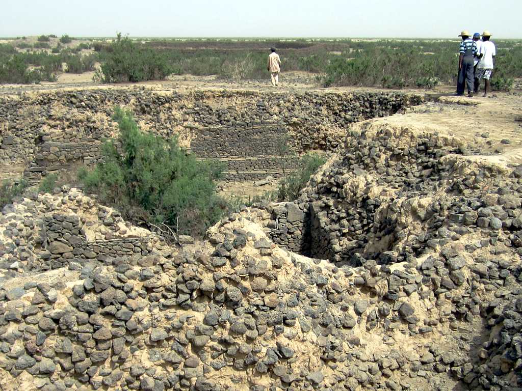
The excavated city provides the strongest corrective to an image of Adulis as an occasional beach market. It must itself be read historically. In 1868, during the British military expedition against Tewodros II, Captain William West Goodfellow oversaw the clearance of a church while Richard Rivington Holmes, the British Museum representative attached to the campaign, documented the work and helped remove finds. Roberto Paribeni excavated at Adulis under Italian colonial rule in 1906; Francis Anfray returned in the 1960s; Eritrean and international teams have since employed stratigraphic excavation, environmental sampling, remote sensing and digital recording. Each campaign opened different areas with different questions and standards. Museum dispersal and incomplete documentation still shape what can be known.16
The plan familiar from publications is therefore a plan of exposure, not a map of the whole ancient settlement. Nor are inherited labels such as “palace,” “temple” and “cathedral” innocent descriptions. A large building proves investment before it proves royal residence; a basilical form supports, but does not exhaust, a building’s social history. These reservations do not diminish the site. Stone buildings, streets, working surfaces, churches and dense deposits document sustained construction and repair on a scale incompatible with a merely transient market.
Daniel Habtemichael has brought the cost of that construction to the centre of the political question. By modelling thirty-nine built forms and estimating their labour requirements, he argues for a locally organised political economy and, more strongly, for an autonomous Adulitan state.17 The first claim is difficult to evade: somebody at Adulis mobilised workers, food, stone, timber and skilled knowledge. The second remains harder to prove. Labour energetics estimate the resources embodied in a structure, not the constitutional location of the authority that commanded them. An independent capital, a privileged commercial community and a wealthy provincial centre can all build impressively. Habtemichael’s intervention is most valuable when it prevents “Aksum” from functioning as an unexplained answer to every sign of coastal organisation.
Religious buildings provide a particularly rich example. Re-excavation of two churches, together with radiocarbon dates and architectural phasing, places their principal development in the sixth and early seventh centuries. Their plans changed over time as liturgical practice and community use changed.18 The dates are later than older stylistic chronologies sometimes allowed. But they should not be converted into the date at which Adulis “became Christian.” Textual traditions refer to a bishop of the Adulites before the monumental phases, while religious affiliation, episcopal organisation and church construction need not proceed in lockstep. Reused materials and changing sacred practices also complicate any clean replacement of one religious world by another.
Figure 2
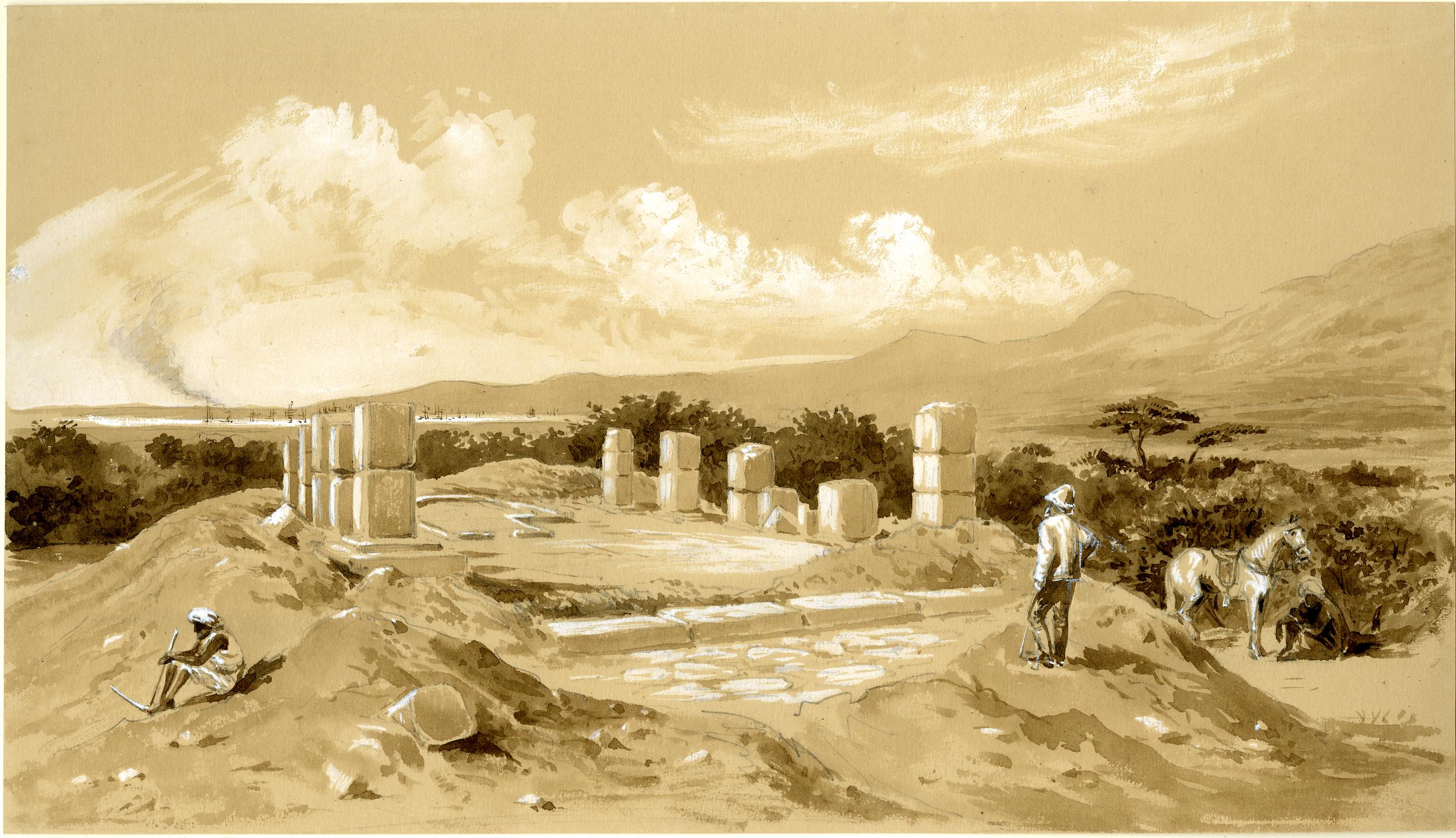
The buildings materialised long-distance connection while making it local. A marble architectural element excavated in 1868 has been identified as Proconnesian, from the quarrying and workshop zone in the Sea of Marmara that supplied major building projects across the late Roman world.19 Its arrival at Adulis required procurement, sea transport, unloading and installation. Whether the marble came by purchase, patronage or diplomatic gift is unknown. Once installed, however, it belonged to an Adulitan building and to the uses its community made of imported prestige. Calling it “Byzantine” without qualification would mistake origin for ownership.
Stone thus stores social effort without naming all those who supplied it. Buildings do not resolve the city’s political status century by century. They show instead that the port contained institutions capable of concentrating labour and distant materials into durable form. That accumulated urban capacity is precisely what made Adulis indispensable to rulers who wished to act beyond the highlands.
Thrones, governors and a war across the sea
The two inscriptions copied for Kaleb expose both the possibilities and the hazards of writing political history from Adulis. The text on the stela commemorated the campaigns of Ptolemy III, who ruled Egypt from 246 to 222 BCE, and referred to elephants obtained in the African region for military use. Its survival at Adulis in the sixth century attests to a Ptolemaic connection and to the extraordinary afterlife of a monument. It does not prove that the later city was a Ptolemaic colony, or that elephants were captured, trained and shipped at a single excavated installation.20
The throne inscription is a separate composition. Cosmas presented it after the Ptolemaic text, but the shift from third to first person and the reference to the author’s twenty-seventh regnal year rule out a continuation by Ptolemy III, who did not reign that long. The unnamed king boasts of campaigns across northeastern Africa and into Arabia, the exaction of tribute, the protection of roads and a final sacrifice at Adulis. Scholars have attributed him variously to an early Aksumite polity, a South Arabian context or an African coastal kingdom shaped by Hellenistic political forms. Proposed dates range widely, though many place the text in the early centuries CE.21
The dispute is not an inconvenience to be passed over. It reveals how easily Adulis is forced into a political map inherited from later centuries. The inscription’s Greek idiom, divine names and conquest geography do not supply a modern nationality. Nor does the fact that the monument stood at Adulis prove that its author’s capital stood there. What can be said is that a ruler chose the city as the place from which to monumentalise a dominion spanning routes to the interior and across the sea. The port was part of the argument of the inscription.
By Kaleb’s reign, the political relationship is clearer. Asbas governed Adulis under the Aksumite king, and royal instructions travelled to him. Yet the episode also shows that commands required local mediation. Kaleb did not dispatch a court scholar from the highlands; his governor found literate visitors already at the port. Adulis supplied the people, objects and setting through which the royal request became usable knowledge.
The same relationship operated on a far larger scale in the war against the Himyarite ruler Yusuf Asʾar Yathʾar, conventionally dated to around 525. Yusuf’s killing of Christians at Najran gave the Aksumite intervention the form of a holy war in surviving Christian accounts. It was also a struggle within the politics of the southern Red Sea, where Aksumite, Himyarite, Roman and Sasanian interests intersected.22 Religious solidarity, dynastic ambition and control of maritime routes need not be treated as mutually exclusive motives.
The Martyrdom of Arethas describes a force carried by about sixty merchant vessels and ten ships built on Kaleb’s orders. Those numbers belong to a hagiographic narrative, not a naval register. They should not be used to conjure a permanent Aksumite battle fleet. They do, however, preserve a revealing distinction between requisitioned commerce and royal construction.23 Even if the total is rhetorical, the logistical problem was real: vessels, crews, soldiers, weapons, provisions and water had to converge at the coast and cross the Bab al-Mandab.
Adulis made such concentration possible. A king could compel, finance or legitimate an expedition, but he depended on a littoral system he had not created from nothing: merchants with ships, seamen with knowledge, carriers linking plateau and coast, officials able to gather supplies, and landing places that could handle sudden demand. Dependence did not make the port sovereign; subordination did not make its capacities derivative. Maritime power was assembled through negotiation between royal command and urban competence.
A city that ended more than once
For a long time, histories disposed of Adulis with a single sentence: Arabs or Muslims destroyed it in the seventh century, often in the year 640. No contemporary source securely records that event, and the archaeology does not furnish a city-wide destruction horizon that can be assigned to a named attacker. Burn layers occur, but fire is an event to be interpreted, not an ethnic signature.24
Stratigraphy and ceramics instead suggest uneven contraction. Some buildings were damaged, altered or ceased to be maintained. Long-distance exchange did not stop at one universally visible date. Gulf storage and transport wares continue to occur in late contexts, and the assemblages excavated through 2025 reinforce the regular, if minority, presence of Sasanian-connected material at late antique Adulis.25 The evidence does not justify extending the classical city indefinitely; it does make a neat mid-seventh-century terminus increasingly difficult to defend.
Environmental change belongs in this account, but not as a solitary cause. Geoarchaeology in the Gulf of Zula records changing channels and substantial fluvial deposition. Sedimentation could make a landing place shallower, shift the most efficient route and raise the labour cost of maintaining connections between shore and town. Such changes interact with political security, taxation, demand, institutional patronage and the redistribution of trade. A harbour landscape is always being made; at some point, maintaining one arrangement may no longer have been worthwhile.26
The wider political economy was changing as well. Roman and Sasanian power retreated from their late antique forms, the early caliphate reorganised Red Sea connections, Aksum’s coinage and monumental investment contracted, and centres of exchange shifted. None of this amounts to an instantaneous closing of the sea. It altered the network in which Adulis had prospered and the kinds of authority able to sustain its urban institutions.27
Later graves make the inadequacy of “abandonment” especially clear. Excavations since 2018 have documented burials in and around the ruins, including graves in the former cathedral dated between the fifteenth and eighteenth centuries and a much larger cemetery of the nineteenth and early twentieth centuries.28 These burials do not demonstrate continuous city life. They reveal something more precise: long after ancient streets and churches had ceased to function, communities returned to the ruins, interpreted them and made them part of a new sacred landscape.
Adulis therefore had more than one ending. A building could fall out of use while the harbour remained active; long-distance trade could diminish while the site retained local meaning; an ancient church could become a Muslim burial place centuries later. The city’s history is not a rise and fall drawn as a single curve, but a series of changing relationships among sea, shore, highland and built space.
Kaleb’s request lets us see those relationships at their most concentrated. He turned to Adulis for an inscription while preparing to turn through it toward Arabia. The city offered him historical language, an administrative presence and the logistical means of projection. To call it “Aksum’s port” is not wrong. It is incomplete in exactly the way an imperial description is incomplete: it names the beneficiary of a system while leaving the people and institutions that made the system work in the background. Bringing the city forward does not sever Adulis from Aksum. It allows us to understand the relationship as an achievement that was contingent, labour-intensive and therefore historical.
Notes
Bibliography
Beeston, A. F. L. “The Authorship of the Adulis Throne Text.” Bulletin of the School of Oriental and African Studies 43, no. 3 (1980): 453–458.
Bowersock, G. W. The Throne of Adulis: Red Sea Wars on the Eve of Islam. Oxford: Oxford University Press, 2013.
Carannante, Alfredo, Clément Flaux, Christophe Morhange, and Chiara Zazzaro. “Adulis in Its Regional Maritime Context: A Preliminary Report of the 2015 Field Season.” Newsletter di Archeologia CISA 6 (2015): 279–294.
Casson, Lionel, ed. and trans. The Periplus Maris Erythraei. Princeton: Princeton University Press, 1989.
Castiglia, Gabriele. “An Archaeology of Conversion? Evidence from Adulis for Early Christianity and Religious Transition in the Horn of Africa.” Antiquity 96, no. 390 (2022): 1555–1573. https://doi.org/10.15184/aqy.2022.136.
Cosmas Indicopleustes. Topographie chrétienne. Edited and translated by Wanda Wolska-Conus. 3 vols. Paris: Éditions du Cerf, 1968–1973.
Fauvelle-Aymar, François-Xavier. “Les inscriptions d’Adoulis (Érythrée): fragments d’un royaume d’influence hellénistique et gréco-romaine sur la côte africaine de la mer Rouge.” Bulletin de l’Institut français d’archéologie orientale 109 (2009): 135–160.
Grathwol, Franziska, Christian Roos, Dietmar Zinner, et al. “Adulis and the Transshipment of Baboons during Classical Antiquity.” eLife 12 (2023): e87513. https://doi.org/10.7554/eLife.87513.
Giostra, Caterina, and Serena Massa. “Dal Mediterraneo al Mar Rosso: la cristianizzazione della città-porto di Adulis e la diffusione di modelli e manufatti bizantini.” Hortus Artium Medievalium 22 (2016): 92–109. https://doi.org/10.1484/J.HAM.5.111334.
Habtemichael, Daniel. Modeling the Local Political Economy of Adulis: 1000 BCE–700 ACE. PhD diss., University of Massachusetts Amherst, 2019.
Hatke, George. Aksum and Nubia: Warfare, Commerce, and Political Fictions in Ancient Northeast Africa. New York: New York University Press, 2013.
Larentis, Omar, Nelly Cattaneo, Paolo Lampugnani, et al. “An Interdisciplinary Analysis of the Late Islamic Cemeteries Within the Cathedral (15th–18th Century CE) and the Ruins of Adulis (Mid-19th–Early 20th Century CE).” Heritage 8, no. 1 (2025): 1. https://doi.org/10.3390/heritage8010001.
Lucarini, Giulio, Donatella Barca, and Andrea Manzo. “The Provenance of Obsidian Artefacts from the Middle Kingdom Harbour of Mersa/Wadi Gawasis, Egypt, and Its Implications for Red Sea Trade Routes in the 2nd Millennium BC.” Quaternary International 555 (2020): 85–95. https://doi.org/10.1016/j.quaint.2020.03.015.
Lusini, Gianfrancesco. “The Decline and Collapse of the Kingdom of Aksum (6th–7th CE): An Environmental Disaster or the End of a Political Process?” In The End of Empires, edited by Michael Gehler, Robert Rollinger, and Philipp Strobl, 321–336. Wiesbaden: Springer VS, 2022.
Manzo, Andrea. “Adulis before Aksum? Possible 2nd and 1st Millennium BC Evidence from the Site of the Ancient Port.” In Current Trends in Eritrean Studies, edited by Gianfrancesco Lusini, 29–42. Naples: Università degli Studi di Napoli “L’Orientale,” 2010.
Munro-Hay, Stuart. “The British Museum Excavations at Adulis, 1868.” The Antiquaries Journal 69, no. 1 (1989): 43–52.
Oleksiak, Jerzy M., Emilia Smagur, Sarah Japp, Davide Gorla, and Serena Massa. “Crossing Non-Existing Borders: Sasanian Material Culture in the Red Sea and South Arabia.” Azania: Archaeological Research in Africa (2026). https://doi.org/10.1080/0067270X.2026.2694205.
Peacock, David, and Lucy Blue, eds. The Ancient Red Sea Port of Adulis, Eritrea: Report of the Eritro-British Expedition, 2004–5. Oxford: Oxbow Books, 2007.
Pliny the Elder. Natural History. Vol. 2, Books 3–7. Translated by H. Rackham. Loeb Classical Library. Cambridge, MA: Harvard University Press, 1942.
Zazzaro, Chiara. The Ancient Red Sea Port of Adulis and the Eritrean Coastal Region: Previous Investigations and Museum Collections. BAR International Series 2569. Oxford: Archaeopress, 2013.
Zazzaro, Chiara, Enzo Cocca, and Andrea Manzo. “Towards a Chronology of the Eritrean Red Sea Port of Adulis (1st–Early 7th Century AD).” Journal of African Archaeology 12, no. 1 (2014): 43–73.
Zerai, Abraham, et al. “The Organic Residues of Lining in Transport Vessels from the Red Sea Coast of Eritrea: A Further Element to Understand Past Commercial Relations.” Heritage Science 10 (2022): 162. https://doi.org/10.1186/s40494-022-00788-9.
Selected sources and further reading
For the port and its archaeology: David Peacock and Lucy Blue’s edited The Ancient Red Sea Port of Adulis remains the essential point of departure for the settlement and harbour landscape. Read it with Chiara Zazzaro, Enzo Cocca and Andrea Manzo’s stratigraphic chronology and Zazzaro’s study of earlier excavations and dispersed collections.
For commerce: Lionel Casson’s edition of the Periplus is indispensable, especially because its commentary makes the Greek terminology and geographical uncertainties visible. Jerzy Oleksiak and colleagues’ 2026 article supplies the most recent published synthesis of Gulf ceramics from excavations through 2025.
For political interpretation: G. W. Bowersock offers a vivid account of the inscriptions and Kaleb’s Arabian war. François-Xavier Fauvelle-Aymar and A. F. L. Beeston demonstrate why the unnamed throne text remains contested. George Hatke is particularly valuable on the rhetoric of conquest and the danger of treating political texts as straightforward territorial maps.
For religion and urban life: Gabriele Castiglia’s study integrates architectural phasing and radiocarbon evidence while resisting a one-event model of conversion. Daniel Habtemichael’s dissertation makes the strongest sustained case for treating Adulis as a political economy in its own right; its argument for independence should be read as a substantive intervention rather than a settled conclusion.
-
Cosmas Indicopleustes, Topographie chrétienne, ed. and trans. Wanda Wolska-Conus, 3 vols. (Paris: Éditions du Cerf, 1968–1973), 2.54–63; A. F. L. Beeston, “The Authorship of the Adulis Throne Text,” Bulletin of the School of Oriental and African Studies 43, no. 3 (1980): 453–458; G. W. Bowersock, The Throne of Adulis: Red Sea Wars on the Eve of Islam (Oxford: Oxford University Press, 2013), 9–17. ↩
-
David Peacock and Lucy Blue, eds., The Ancient Red Sea Port of Adulis, Eritrea: Report of the Eritro-British Expedition, 2004–5 (Oxford: Oxbow Books, 2007); Alfredo Carannante et al., “Adulis in Its Regional Maritime Context: A Preliminary Report of the 2015 Field Season,” Newsletter di Archeologia CISA 6 (2015): 279–294. ↩
-
Periplus Maris Erythraei, §§4–5, in Lionel Casson, ed. and trans., The Periplus Maris Erythraei (Princeton: Princeton University Press, 1989), 51–53. ↩
-
Peacock and Blue, Ancient Red Sea Port of Adulis; Carannante et al., “Adulis in Its Regional Maritime Context.” ↩
-
Casson, Periplus, 271–276; Peacock and Blue, Ancient Red Sea Port of Adulis, esp. discussion of the harbour and emporion nomimon. ↩
-
Andrea Manzo, “Adulis before Aksum? Possible 2nd and 1st Millennium BC Evidence from the Site of the Ancient Port,” in Current Trends in Eritrean Studies, ed. Gianfrancesco Lusini (Naples: Università degli Studi di Napoli “L’Orientale,” 2010), 29–42. ↩
-
Giulio Lucarini, Donatella Barca, and Andrea Manzo, “The Provenance of Obsidian Artefacts from the Middle Kingdom Harbour of Mersa/Wadi Gawasis, Egypt, and Its Implications for Red Sea Trade Routes in the 2nd Millennium BC,” Quaternary International 555 (2020): 85–95, https://doi.org/10.1016/j.quaint.2020.03.015. ↩
-
Franziska Grathwol et al., “Adulis and the Transshipment of Baboons during Classical Antiquity,” eLife 12 (2023): e87513, https://doi.org/10.7554/eLife.87513. ↩
-
Periplus, §§4–6, Casson, Periplus, 51–55. ↩
-
Periplus, §5, Casson, Periplus, 53. ↩
-
Pliny the Elder, Natural History 6.173–174. The chapter-level citation often used is 6.34. ↩
-
Periplus, §6, Casson, Periplus, 53–55. ↩
-
Jerzy M. Oleksiak et al., “Crossing Non-Existing Borders: Sasanian Material Culture in the Red Sea and South Arabia,” Azania: Archaeological Research in Africa (2026), https://doi.org/10.1080/0067270X.2026.2694205. ↩
-
Abraham Zerai et al., “The Organic Residues of Lining in Transport Vessels from the Red Sea Coast of Eritrea: A Further Element to Understand Past Commercial Relations,” Heritage Science 10 (2022): 162, https://doi.org/10.1186/s40494-022-00788-9. ↩
-
Pliny, Natural History 6.173; Cosmas, Topographie chrétienne, 2.56–63. ↩
-
Stuart Munro-Hay, “The British Museum Excavations at Adulis, 1868,” The Antiquaries Journal 69, no. 1 (1989): 43–52; Chiara Zazzaro, The Ancient Red Sea Port of Adulis and the Eritrean Coastal Region: Previous Investigations and Museum Collections (Oxford: Archaeopress, 2013). ↩
-
Daniel Habtemichael, Modeling the Local Political Economy of Adulis: 1000 BCE–700 ACE (PhD diss., University of Massachusetts Amherst, 2019), https://scholarworks.umass.edu/entities/publication/6c43531e-c4e4-49d3-9a9b-ed7063f13765. ↩
-
Gabriele Castiglia, “An Archaeology of Conversion? Evidence from Adulis for Early Christianity and Religious Transition in the Horn of Africa,” Antiquity 96, no. 390 (2022): 1555–1573, https://doi.org/10.15184/aqy.2022.136. ↩
-
Caterina Giostra and Serena Massa, “Dal Mediterraneo al Mar Rosso: la cristianizzazione della città-porto di Adulis e la diffusione di modelli e manufatti bizantini,” Hortus Artium Medievalium 22 (2016): 92–109, https://doi.org/10.1484/J.HAM.5.111334; Zazzaro, Ancient Red Sea Port of Adulis, 118–125. ↩
-
Cosmas, Topographie chrétienne, 2.56–63; Bowersock, Throne of Adulis, 9–17. ↩
-
Beeston, “Authorship”; François-Xavier Fauvelle-Aymar, “Les inscriptions d’Adoulis (Érythrée): fragments d’un royaume d’influence hellénistique et gréco-romaine sur la côte africaine de la mer Rouge,” Bulletin de l’Institut français d’archéologie orientale 109 (2009): 135–160; Bowersock, Throne of Adulis, 17–34. ↩
-
Bowersock, Throne of Adulis, 75–86. For the broader political setting and the evidentiary limits of Christian narratives, see also George Hatke, Aksum and Nubia: Warfare, Commerce, and Political Fictions in Ancient Northeast Africa (New York: New York University Press, 2013). ↩
-
Martyrdom of Arethas, discussed in Bowersock, Throne of Adulis, 75–86, and Peacock and Blue, Ancient Red Sea Port of Adulis. ↩
-
Chiara Zazzaro, Enzo Cocca, and Andrea Manzo, “Towards a Chronology of the Eritrean Red Sea Port of Adulis (1st–Early 7th Century AD),” Journal of African Archaeology 12, no. 1 (2014): 43–73. ↩
-
Oleksiak et al., “Crossing Non-Existing Borders.” ↩
-
Carannante et al., “Adulis in Its Regional Maritime Context.” ↩
-
Gianfrancesco Lusini, “The Decline and Collapse of the Kingdom of Aksum (6th–7th CE): An Environmental Disaster or the End of a Political Process?,” in The End of Empires, ed. Michael Gehler, Robert Rollinger, and Philipp Strobl (Wiesbaden: Springer VS, 2022), 321–336, https://doi.org/10.1007/978-3-658-36876-0_15. ↩
-
Omar Larentis et al., “An Interdisciplinary Analysis of the Late Islamic Cemeteries Within the Cathedral (15th–18th Century CE) and the Ruins of Adulis (Mid-19th–Early 20th Century CE),” Heritage 8, no. 1 (2025): 1, https://doi.org/10.3390/heritage8010001. ↩